

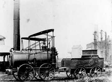
Sorry about the appalling pun in the title but after researching the history of Stourbridge locomotives we became fascinated with the legendary Shutt End line, so why is it so important to Stourbridge history and where is it? We didn't have a clue so to answer the first question we asked local historian Dr Paul Collins, his reply was that it was the first railway line in the Midlands and Southern region of England to run a steam locomotive - The Agenoria, which can now be seen in the National Railway Museum in York. The Agenoria ran on the Shutt End line from 1829 to the 1864. Please be aware that this is totally our own research and we know next to nothing about the history of trains, so if there are any experts out there you are more than welcome to contribute or correct us. So where did the line run from, and where to, and why? It is important to point out that you cannot walk the line as such, much of the line has now vanished and the route runs across industrial, suburban and rural areas. Consequently we had to get permission to take some of the photos that you see below as they were taken on private land.
Whereas the Stourbridge Lion locomotive was spirited away to America as soon as it was built, the Agenoria worked for many years on the Shutt End line, carrying coal and bricks from the mines and factories in the Pensnett area down to the canal at Greensforge at what is now called Ashwood Marina (Flotheridge Basin on the old map), south of Kingswinford. It has to be said that even though the Stourbridge locomotives were eclipsed by the superior technology of Stephensons Rocket, in many ways Stourbridge was at the cutting edge of technology in the early 1800's, a real Black Country silicon valley!
The first thing we did was to read Dr Paul's book, "Stourbridge and it's locomotives", published in 1989 in conjunction with Dudley Leisure Services, and we thank Paul for his permission to repeat some of the text from his book. Here's the section below that explained the need for building the Shutt End line in the first place. You can also download the chapter from his book.
"In the 1820s the coal pits of the Pensnett area on the Western edge of the Black Country depended for their future growth upon their ability to transport coal to the expanding industrial sites in Britain. The key to their success in this respect was to get the coal to the Staffordshire & Worcestershire (Staffs & Worcs) Canal which was one of the main north-south transport arteries of the time. This canal, which had been opened in 1772, lay some three miles to the west of Pensnett, although the slightly later (1779) Stourbridge Canal, which connected with the Staffs & Worcs at Stourton, passed within one mile of the Pensnett coal field on its way to Dudley. Logic would seem to suggest that a spur from the Stourbridge Canal to Pensnettwould solve any transport problems (one was in fact built in 1840) but travel along the Stourbridge Canal would still have been very slow due to the number of locks in the area. The local mineowners, in an attempt to overcome these problems, conceived the idea of building a railway to run directly from the coal area to the Staffs & Worcs canal. Railways or tramways were by no means a new idea in the area (indeed the first ever use of the term 'railway' is reputed to have been in the Pensnett area in 1681) although narrow gauge lines employing horse traction were the order of the day."
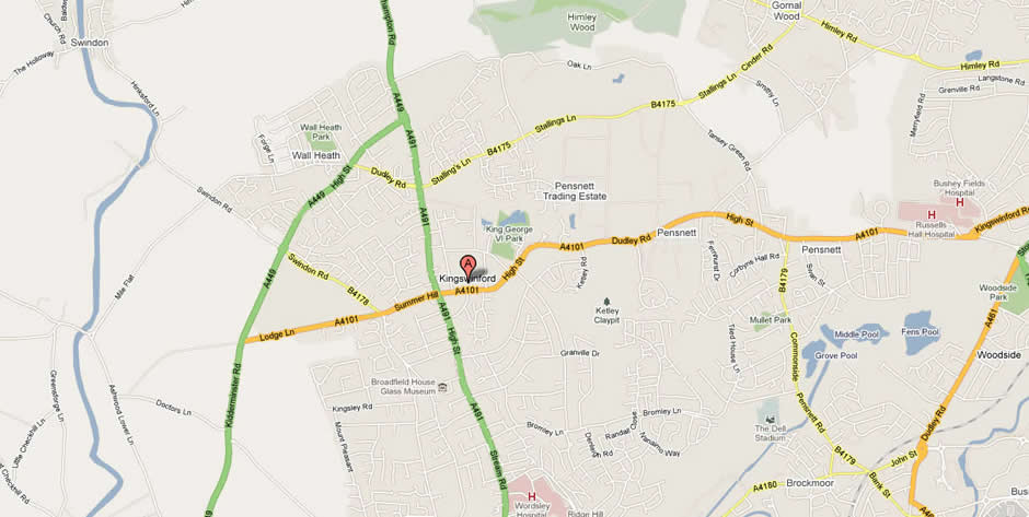
Then we located an online map showing the line in the 19th century, and for this we thank Dr Humphrey Southall of the Great Britain Historical GIS Project at the University of Portsmouth, who has granted permission to use a part of the map of the area, as displayed on their website A Vision of Britain through Time.
 1900
1900
 Today
Today
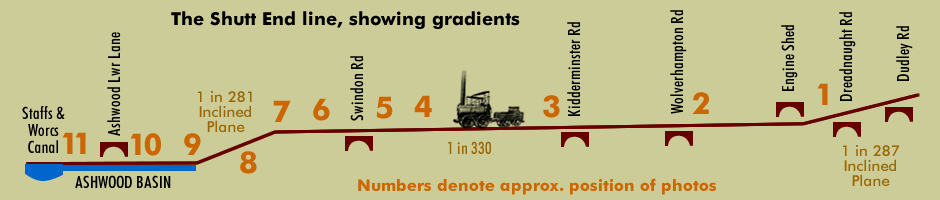
Drag the slider across (Flash users only) and you will see how the route of the line appears in relation to a map of the same area today. Thanks also go to James Tromans of Siteace for his programming skulduggery in Flash to achieve this great effect, way too clever for us! The map clearly shows the Shutt End line running to the north of Kingswinford centre, you can just make out the words SHUTT END centre right of the map and FLOTHERIDGE BASIN (Ashwood Marina) to the far left of the map where the line ended at the canal, a total length of less than four miles. As you operate the slider it's amazing how similar the road network is to how it was in the late 1800s. This made it pretty easy to work out where the remains of the line are, please see the photos below, click to open a larger version with a few words of description. The line employed two "inclined planes", see diagram below, recreated with thanks to Dr Paul Collins and the contributors to his book. Paul goes on to say about the line:
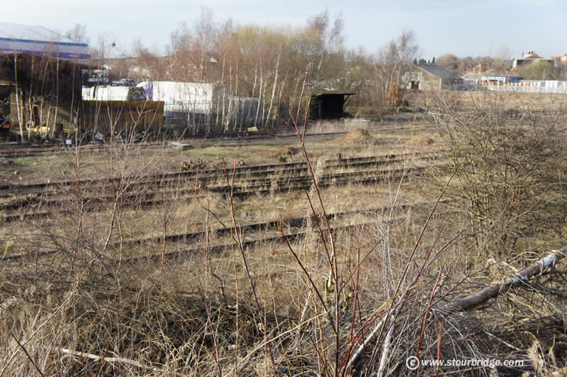
1 - There is a large area of disused railway lines right next to the Eastern end of the Pensnett Trading Estate close to Dreadnaught Road. This appears to be close to where the Shutt End line started from, servicing collieries such as Corbyns Hall, owned by Viscount Dudley. This would be roughly the site of the first inclined plane, although you would not think so from the photo! To this day there is a Corbyns Hall Road nearby.


4 - The original embankment can be clearly seen at the end of Farrier Way in Wall Heath


11 - Looking down the length of Ashwood Marina, at 760 yards in length it could accommodate up to 60 canal boats at a time, showing the truly industrial scale of the operation at its height. Today Ashwood Marina is a thriving centre for the canal boat industry.