
Schools and Colleges | Shopping | Clubs and Charities | Genealogy | Stourbridge Area | Business | Links | Lots more stuff | Contact | Homepage
Kinver Village & Kinver Edge
Kinver is a beautiful
village just 5 minutes drive away from Stourbridge. The River Stour that
gave Stourbridge its name also runs alongside the village. The existence
of the village was first recorded in 736AD as CYNIBRE, meaning "great
hill". There is an abundance of fantastic old buildings in and around
the village, such as the old Grammar School and the Whittington Inn. Please
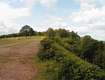
see photos below. But perhaps even more impressive is Kinver Edge, three
hundred acres of national trust land within easy walking distance of the
village itself. Kinver Edge, like nearby Clent
Hills, was once the nearest thing Stourbridge people had to a holiday,
if you had no money, you walked it, if you had some money, you took the
tram! The tramway started in Amblecote, Stourbridge and travelled though
lovely scenery to the village of Kinver itself. Sadly the tramway was
removed many years ago, today only grandparents remember it. In time we
may devote more of this section to the tramway, meanwhile please
contact us if anyone has any recollections of it they would like to
share.
Website: Kinver
Online
National Trust website: https://www.nationaltrust.org.uk/kinver-edge-and-the-rock-houses
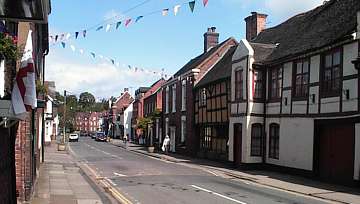
Kinver High Street
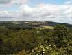
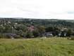
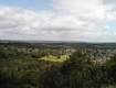
The views from the top of Kinver Edge are wonderful. It is a sandstone ridge just several hundred feet high, with views out over surrounding fields and woodland. It is easy to imagine this being the inspiration for Tolkein's "Middle Earth" landscape, being a Midlander himself perhaps it was! The soft sandstone is easy to carve and a distinctive feature of the Edge is the abundance of caves and former houses carved from the many rocky outcrops. People lived in these cave houses up to the 1960's.
To see more of Kinver please click on any of the small images below, or click on any of the 3 viewpoints on the map for 3D panoramas.


Stourbridge Lion | Music | Sport | Long Lost Friends | Clubs and Charities | Pubs || Schools and Colleges
Genealogy | Stourbridge Area | Business | Links | Lots more stuff | Contact | Homepage